


Rocher blanc

oliviergau
User
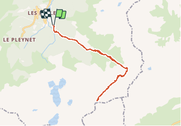

Length
16.9 km

Max alt
2842 m

Uphill gradient
1687 m
Km-Effort
39 km

Min alt
1124 m

Downhill gradient
1707 m
Boucle
Yes
Creation date :
2021-03-20 06:05:54.787
Updated on :
2021-03-20 11:54:01.445
4h32
Difficulty : Very easy

FREE GPS app for hiking
 SityTrail
IGN / Geographical institutes
SityTrail Plus
The world is yours!
About
Trail Touring skiing of 16.9 km to be discovered at Auvergne-Rhône-Alpes, Isère, Le Haut-Bréda. This trail is proposed by oliviergau.
Positioning
Country:
France
Region :
Auvergne-Rhône-Alpes
Department/Province :
Isère
Municipality :
Le Haut-Bréda
Location:
La Ferrière
Start:(Dec)
Start:(UTM)
270936 ; 5018097 (32T) N.
Comments